Dublin Dashboard Launch, 10:30-1.00pm, Friday 19th September

dashboardinviteimage

We would like to invite you to the launch of the Dublin Dashboard.

The Dublin Dashboard provides citizens, public sector workers and companies with real-time information, time-series indicator data, and interactive maps about all aspects of the city.  It enables users to gain detailed, up to date intelligence about the city that aids everyday decision making and fosters evidence-informed analysis.

The Dublin Dashboard pulls together data from major data sources — including Dublin City Council, Dublinked, Central Statistics Office, Eurostat, and government departments, and links to a variety of existing applications — to provide thousands of interactive data visualisations. The underlying data is freely available so others can undertake their own analysis and build their own applications and visualisations.

The Dublin Dashboard has been produced by The Programmable City project and AIRO at Maynooth University, working with Dublin City Council, and has been funded by the European Research Council and Science Foundation Ireland.

The event will take place in Wood Quay, Dublin City Council on Friday, 19th September 2014.  Registration will start at 10.30am, and Owen Keegan, Chief Executive of Dublin City Council, will officially open the event at 11.00am, which will close no later than 13.00.

THE EVENT IS NOW FULLY BOOKED!

Email: nirsa@nuim.ie; Telephone: (01) 708 3350 

Many thanks,

Prof. Rob Kitchin,
ERC Advanced Investigator, The Programmable City project.

DublinDashboardInvite

Wearing the Self

The world (or just fanboys) will soon be waiting with baited breath as Apple launches its entry into the wearable technology market with the release of the iWatch.

Apple's HealthKit interface

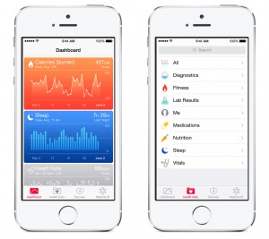
Apple’s HealthKit interface

With the bundling of the Apple HealthKit into iOS8, the trailblazers of the mobile digital technology industry have moved into the hybrid mobile/wearable space, and towards a wearable rather than haptic interface future for mobile technology.

The intertwining of mobile and wearable technology is in tandem with the tethering of these technologies to the body and to the vast databanks and data analytic algorithms of big data companies that use this information to assess the trends and predictabilities of everyday life. We term these technologies as enablers of the “quantified self”. The quantified self is itself a product of the continual measuring of datapoints harvested from the individual and continually compared to the measured past and a predicted future. On a different tack, the ever reliable Adam Curtis has recently argued that digital tracking technologies – the bedrock of the big data driven smart city – are responsible for holding people in a digitally-engineered stasis. Curtis traces a genealogy of the development of surveillance and spying technologies and relates this to growing paranoia and control in governance that can only be sated eventually by the algorithmic governance afforded by digital technology. In the present day, these hidden digital technologies and systems in effect freeze time by virtue of their withdrawn operations and recording and representations of the present, while comparing that present to the recorded past. The aim of such systems is “to discover patterns, coincidences and correlations, and from that find ways of stopping change”. The cumulative effect of the wealth of systems involved in cryptographic governance of our lives (consumerism, managing the body, the global financial system etc…) is, according to Curtis, to govern into a state of immobility that is responsible for perpetually repeating the past and that is terrified of change.

While Curtis’ arguments are open to critique and discussion far beyond what I will offer here, they do allow for a consideration of what kinds of spaces are being created for users and people subjected to these technologies. In this post I want to focus on the notion of data collecting technologies being a critical part of a logic of artificial homeostasis in the smart city, and what this might mean for us as critical theorists, geographers and philosophers. The state of immobility identified by Curtis is in opposition to the idea that we should be looking at new

Almost certainly what the iWatch will not look like. Source: wearechampionmag.com

Almost certainly what the iWatch will not look like. Source: wearechampionmag.com

and altered mobilities that are emerging through the continual co-presence of digital technology. As a phenomenologist, I am particularly interested in this with relation to the phenomenological appreciation of place and how these “technologies of immobility” may affect how place is experienced. In particular, the use of technologies that are involved in the production of information for the “quantified self” are of interest; these are technologies that on the whole promise benefits to the user through a disciplining to achieve a particular goal. As such, the notion of recording and comparing that Curtis bemoans is a feature of this kind of technology. Some key theorists have engaged with quantifiable self technology with regards to the spatialities and mobilities that they afford, and here I want to consider what kind of subjective experiences of space may arise from an ubiquitous presence of these technologies. Briefly, I will consider this utilising a three-faceted framework. Firstly, technologies of management of the body (as one of the categories of technology that Curtis considers so critical in this stasis-inducing milieu) will be positioned within Foucault’s notion of technologies of the self. From there, those technologies are scrutinised with regards to the intentionality or logics of digital media, drawing on Friedrich Kittler. Finally, I offer some a challenge for a research agenda that will allow for a greater understanding of these issues.

Foucault’s Technologies of the Self is (in my reading) the most Nietzschean of Foucault’s works, even given the genealogical roots of Foucault’s accounts of the development of human sexuality or panoptical society that relates closely to Nietzsche’s genealogy of morality. I position Foucault NietzscheTechnologies of the Self as Nietzschean because of the clear line between the Apollonian and Dionysian views of the self that are presented, and how Foucault argues that technologies of the self have obscured the concept of the self. This obscuring comes from ancient Greek paradigm shifts from a “take care of yourself” view of the self to a “know yourself” view. In this, the concern for the soul and the self as soul is replaced or obscured with the technologies of writing and recording of the activities of the body as a way of “knowing thyself”. In essence, the need for contemplation and self-examination that Socrates relays as critical to Alcibiades in the dialogue Alcibiades is replaced with journalling and historicising the activity of the person. The self though is not clothing, tools or possessions; it is to be found in the principle that uses these tools (Foucault, 1988: 17). The types of technologies that are grouped in the quantified self debate are therefore technologies of “know thyself” where thyself is quantified and represented in a quantified form.

The impact of quantifiable self technologies is to conduct an abstraction of previously hidden or withdrawn human processes as data by wearable technologies, and to hermeneutically position this information as the self. The process of abstraction reveals human processes that then become both the conscious concern of the user and a commodity that can be used to reshape behaviour and potentially be used in the commodity form as a source of revenue or profit. The technologies are of course increasingly popular, networked gadgets that are part of the popular discourse on the emerging “Internet of Things” where data collection on an industrial (or some might argue super-industrial) scale can be enabled through the close integration of networked technology to the body and other entities. Berry (2014: 14) argues that such technology is indicative of the emergence of a new industrial internet, “a computational, real-time streaming ecology that is reconfigured in terms of digital flows, fluidities and movement”. Wearable technologies fit in this vision through their constant harvesting of information on the body and the user and the sharing and representation of that data. While the user may receive information on their behaviours that can assist in behavioural changes or adaptations, the information garnered from the total users of a device can be used in aggregated form to inform decision making, planning or predictions on behaviour and movement in emergent “smart cities” where “big data” informs the everyday management of the environment (Greenfield, 2013; Townsend, 2013).

The uses of these common and popular forms of this technology are in themselves well documented but worth commenting upon with regards to what “self” is presented. Jawbone’s “Up” promises to track how a user sleeps, moves and eats and then relays the data back to the user in order to promote their health, the Nike Fuel wristband (discontinued in April 2014) or the Fitbit wristband which makes similar promises to the Jawbone “Up”, with the potential added bonus of rashes or burns when using the Force model (Cambell-Dollaghan, 2014). Forthcoming consumer devices such as Google Glass will allow for an array of self-analysis; the Apple iWatch will already integrate with the extensive HealthKit to record, represent and relay the physical minutia of everyday life to the user.

Wilson (2012: 857) argues that process of data production in cities (such as quantified self technology) are afforded legitimisation through processes of standardisation and objectification, and that these processes in turn transduct (Dodge and Kitchin, 2012) urban space. Wilson expands on this view in this presentation from the Programmable City Launch. While Wilson’s argument concerns the physical characteristics of the city, rather than the processes that underlie human physical presence in the world, the two processes identified are useful in identifying the underlying logic behind wearable technologies and the arguments purported here. Standardisation refers both to the use of standardised technological artefacts and standardised processes used in the abstraction and collection of data concerning a physical entity. Wearable technologies are in themselves a medium that has an internal logic of the production, processing and furthering of data. This resonates with this view of internet-enabled computational devices as part of a wider framework of devices that perform bespoke, discreet tasks in the world and affect subjectivity and human perception accordingly.

Such an approach to media technology as causing alterations in human behaviour is part of a long tradition in theory, from McLuhan’s (2008) famous arguments that media are an extension of man in the world and the medium is the message, when one wants to assess the effects of media on human behaviour and society to Kittler’s (1999) argument that media structures “human affairs” through the production, processing, transmission and storage of data. The standardisation of process through the concretisation of the form of the device and the standard encoding and storage of data is in itself a standardisation of the abstraction of data. Objectification is the product of this standardisation; the abstraction of data from the body (such as heart rate, metabolic data, data on sleep patterns etc.) objectifies information that was previously beyond the conscious awareness of the user and presents that data in a form which can be operationalised.

As such, the internal logic of this technology is both to harvest and share information. The goal of this logic could be argued to be the behavioural change of the user towards a desired behavioural or physical state (i.e. more active or fitter). However, this is contingent a number of factors, such as motivation, time to engage in activity or physical ability. The logic of the creation and continuation of a data stream that shapes human affairs a la Kittler (1999) is a more solid and arguable position. From this view, it is argued that the media device (the wearable technology) is responsible for an ordering of the human in the world. In this case, the ordering is threefold: the human perception of the body is reordered; the human perception of the world itself is reordered through the alteration of the perception of the body and through the role of the body in perceiving the world; and subjective notions of spatiality and mobility are altered as the body is enrolled into the role of connected consumer that comes from the use of wearable technologies. Wearable technology is both co-existing with the body but also responsible for a revealing of the internal mechanisms of the body that would be previously have been hidden or withdrawn from consciousness. The revealing of these processes and bodily functions is problematic; while the representation of particular functions is an expressed aim of the technology, the harvesting of this information is a both a privacy issue in that the knowledge of such processes has bypassed an appreciation by the person and an issue of subjective knowledge of self and world.

The data on the “self” has immediately moved from a hidden, withdrawn state to a shared, commoditised representation of the functions of the body that can be used to shape behaviour, understanding and self-appreciation. The “self” itself is problematised, and the mobility and subjective spatiality of the self in the data-infused environment becomes an issue. What kind of “self” is being presented through these technologies? Should I be wearing a shiny new iWatch with my health and fitness information continually measured and available at a flick of the wrist, what does this mean to the sense of space that I have when I move through the world? It is tempting to offer a view of the subjective experience of world as a solipsistic, self-enclosed bubble where the measuring of self goes with an angst engendered by continual surveillance of the once hidden internal states of the body. Research into the subjective, phenomenological experience of the world when using this technology is needed, and needed now to understand the existential effects of living to “know thyself”.

Bibliography and further reading

Berry, David M., 2014. Critical Theory and the Digital. London: Bloomsbury Academic

Campbell-Dollaghan, Kelsey, 2014. FitBit is recalling all Force Wristbands. Gizmodo http://www.gizmodo.com.au/2014/02/report-fitbit-is-recalling-all-force-wristbands/

Curtis, Adam, 2014. NOW THEN. http://www.bbc.co.uk/blogs/adamcurtis/posts/NO-FUTURE

Dodge, Martin and Rob Kitchin, 2012. Code/Space: software and everyday life. Cambridge: MIT Press

Foucault, Michel, 1988. Technologies of the Self http://cognitiveenhancement.weebly.com/uploads/1/8/5/1/18518906/technologies_of_self_michel_foucault.pdf

Greenfield, Adam, 2013. Against the Smart City. London: Verso

Kittler, Friedrich, 1999. Gramophone, Film, Typewriter. Stanford: Stanford University Press

McLuhan, Marshall, 2008. Understanding Media. London: Routledge

Nietzsche, Friedrich, 1887. On the Genealogy of Morals http://www.inp.uw.edu.pl/mdsie/Political_Thought/GeneologyofMorals.pdf

Plato. Alcibiades. http://www.gutenberg.org/ebooks/1676

Townsend, Anthony, 2013. Smart Cities: Big Data, Civic Hackers and the Quest for a New Utopia. New York: WW Norton and Co.

Digital Geography

Last Friday I acted as a discussant for three sessions (no. 1, no. 2, no. 3) on Digital Geography presented at the RGS/IBG conference in London.  The papers were quite diverse and some of the discussion in the sessions centred on how to frame and make sense of digital geographies.

In their overview paper, Elisabeth Roberts and David Beel categorised the post-2000 geographical literature which engages with the digital into six classes: conceptualisation, unevenness, governance, economy, performativity, and the everyday.  To my mind, this is quite a haphazard way of dividing up the literature.  Instead, I think it might be more productive to divide the wide range of studies which consider the relationship between the digital and geography into three bodies of work:

Geography of the digital

These works seek to apply geographical ideas and methodologies to make sense of the digital.  As such, it focuses on mapping out the geographies of digital technologies, their associated socio-technical assemblages and production.  Such work includes the mapping of cyberspace, charting the spatialities of social media, plotting the material geographies of ubiquitous computing, detailing the economic geographies of component resources, technologies and infrastructures, tracing the generation and flows of big data, and so on.

Geography produced by the digital

This body of work focuses on how digital technologies and infrastructures are transforming the geographies of everyday life and the production of space.  Such work includes examining how digital technologies and ICTs are increasingly being embedded into different spatial domains – the workplace, home, transport systems, the street, shops, etc.; how they mediate and augment socio-spatial practices and relations such as producing, consuming, communicating, playing, etc; how they shape and remediate geographical imaginaries and how spaces are visioned, planned and built; and so on.

Geography produced through the digital

An increasing amount of geographical scholarship, praxis and communication is now undertaken using digital technologies.  For example, generating, recording and analyzing data using digital devices and associated software and databases; the collection and sharing of datasets and outputs through digital archives and repositories; discussing ideas and conducting debate via mailing lists and social media; writing papers and presentations, producing maps and other visualizations using computers; etc.  A fairly substantial body of work thus reflects on the difference digital technologies make to the production of geographical scholarship.

Taken together these three bodies of work, I would argue, constitute digital geography.

At the same time, however, I wonder about the utility of bounding digital geography and corralling studies within its bounds.  To what extent is it useful to delimit it as a defined field of research?

It might be more productive to reframe much of what is being claimed as digital geography with respect to its substantive focus.  For example, examining the ways in which digital technologies are being pervasively embedded into the fabric of cities and how they modulate the production of urban socio-spatial relations is perhaps best framed within urban geography.  Similarly, a study looking at the use of digital technology in the delivery of aid in parts of the Global South is perhaps best understood as being centrally concerned with development geography.  In other words, it may well be more profitable to think about how the digital reshapes many geographies, rather than to cast all of those geographies as digital geography.

Nonetheless, it is clear that geographers still have much work to do with respect to thinking about the digital.  That is a central task of my own research agenda as I work on the Programmable City project.  I’d be interested in your own thoughts as to how you conceive and position digital geography, so if you’re inclined to share your views please leave a comment.

Preservation of Geospatial Data Primer

This document (French and English) is the last in a series that I wrote while in Canada on the preservation of geospatial data and I just received the finals today.  Fitting, since I have now been in Ireland for exactly one year today.  The past is however always part of the present and the future is it not?  In my view, the preservation of data should be part of any spatial data infrastructure and open data strategy.  It is simply part of the lifecycle management of a nations knowledge resources.  Data are modern artifacts as important as manuscripts, films or paintings.  If we invest so much in their capture, then we should also invest in their long term maintenance.

This primer is part of a series of Operational Policy documents developed by GeoConnections intended to inform Canadian Geospatial Data Infrastructure (CGDI) stakeholders about the nature and scope of digital geospatial data archiving and preservation and the realities, challenges and good practices of related operational policies.  GeoConnections produces a number of excellent documents on a wide range of contemporary data topics such as VGI, managing sensitive environmental data, data licences, data access, best practices for sharing data, open source, and a host of many others that are very relevant to governments world wide.

This primer starts by examining preservation responsibilities, legislation, acts, directives and policies.  3 preservation frameworks were also discussed:

  1. the Reference Model for an Open Archival Information System (OAIS) (CCSDS, 2012), developed by the Consultative Committee for Space Data Systems (CCSDS);
  2. the European Long Term Preservation of Earth Observation Space Data: European LTDP Common Guidelines (LTDP Working Group, 2012), developed by the Long Term Data Preservation (LTDP) Working Group of the Ground Segment Coordination Body (GSCB); and
  3. the Trustworthy Repositories Audit & Certification (TRAC) Audit and Certification: Criteria and Checklist (OCLC and CRL, 2007), developed by the Center for Research Libraries and the Online Computer Library Center, Inc.

The stucture of the document loosely follows the The International Research on Permanent Authentic Records in Electronic Systems (InterPARES) 2 record creator and preserver guidelines.  The work is grounded in the stufy of four cases were and includes challenges and best practices :

  1. The Canada centre for Remote Sensing (CCRS) Earth Observation Data Management System (EODMS)
  2. Land Information Ontario (LIO) Geographic Information Archive (GIA)
  3. Department of Fisheries and Oceans Canada (DFO), the Integrated Science Data Management Service (ISDM)
  4. International Polar Year (IPY) Data Preservation

Finally, the section on Establishing a Geospatial Data Preservation System guides data creators and preservers through a series of processes based on the frameworks, case studies, and guidelines.

GeoConnections has been studying the preservation and archiving of geospatial data since 2005. The following are the three reports in this series.

  1. Archiving, management and preservation of geospatial data summary report and recommendations (2005)
  2. Geospatial Data Archiving and Preservation – Research and Recommendations Executive Summary. (2011), Tracey P. Lauriault and Ed Kennedy, Hickling Arthurs and Low (HAL) NOTE – if you email me or GeoConnections, we can send you the full document.
  3. Geospatial Data Preservation Primer GeoConnections (2013) Tracey P. Lauriault, Ed Kennedy, with digital preservation subject matter expertise from Yvette Hackett, Library and Archives Canada Retired, reviewed by Marcel Fortin, Geographic Information Systems (GIS) & Map Librarian. Map and Data Library, University of Toronto. Hickling Arthurs and Low (HAL)

These documents are not for the faint at heart, but they inform practioners in all sectors, they are governmentality in action and are the datasets upon which critical data studies take shape.


The Data Revolution book published

Rob Kitchin’s latest book The Data Revolution: Big Data, Open Data, Data Infrastructure and Their Consequences was published on August 23rd by Sage.  There’s a dedicated website with a bunch of resources (including open access links to related papers and a hyperlinked bibliography), plus a promo video (below).  The publisher has made the preface and chapters one (Conceptualising Data) and four (Big Data) open access.  The website has a full table of contents and chapter outlines though the title gives a pretty good description as to what it’s about.  The book has had a decent amount of advance praise.  The site includes details about buying the book, including electronically through just about every format going.

Sketching the Open Data Landscape in Ireland

by: Tracey P. Lauriault

Note – I have received some feedback since last night and have updated the post accordingly.  Thanks to those who provided it!

DPERThe Republic of Ireland, Department of Public Expenditures and Reform (DPER) launched its first Open Data Pilot Portal data.gov.ie on July 22nd.  The new portal was created by INSIGHT Galway who answered the DPER call for tender of January 24, 2014.  The following suite of products were delivered on April 7th and officially approved by the Government on July 1st.  This is an important milestone.

data.gov.ie DPER/INSIGHT Research Documents:

  1. Best Practice Handbook
  2. Data Audit Report
  3. Roadmap
  4. Evaluation Framework
  5. Open Data Publication Handbook

On the following day, July 23rd, the Government released Ireland’s first Open Government Partnership (OGP) National Action Plan.  The newly launched data.gov.ie portal falls within Ireland’s OGP Plan under section 4 entitled: Open Data and Transparency – opening-up Government data for greater accountability, improving public services and achieving economic growth.  It was also something civil society, academia and government have been advocating for, for some time.

OGPIreladThe first draft of this plan was released at the OGP European Regional Meetings held in Dublin in May of 2014, and part of the package of deliverables listed above are related to Ireland’s May 2013 commitments to join the OGP.  The Government also aspires to sign onto the G8 Open Data Charter.  The OGP plan was informed by a number of stakeholders from civil society, academia and the public and private sectors.  The documentation related to this process is available on the OGP page for Ireland and on the Open Knowledge Foundation Ireland website.  There are many strategies in these reports, if implemented, will greatly make government more accessible and transparent to the public.

Subsequently, the DPER invited members of the public service, involved with the production and dissemination of public sector data in Ireland, to attend an information session, held on the 29th of July, to discuss the documents, the portal, to solicit feedback on the development of an open data strategy for the Republic and to seek support.  A public briefing will also be held September 8th with civil society stakeholders and the public who have been actively engaged in the production of the OGP DRAFT Plan and engaged in Open Data and open government in Ireland.

This blog post is the first of a three part series on open data.

  1. This post sketches part of the open data landscape for the past 5 years.
  2. The next post will discuss the DPER/INSIGHT documents, the portal and provide recommendations.
  3. The final will discuss the open government plan.

Sketching the Open Data Landscape in Ireland

Members of the Programmable City Project have been actively engaged in the theory and practice of open data and making data accessible in both Ireland and Canada for 15 years.  As part of this ERC funded Project researchers are producing open data genealogies and data assemblages for Ireland, Canada and Boston in the US.  The following is but a sketch of the open data landscape in Ireland.  In the last 5 years much important work has been done prior to the DPER launch and it important to feature some of this work as it provides context to the Irish Open Data Story.

The public sector in collaboration with the private and academic sectors have been advocating for both open data and open government for some time.  opendatawkggrp-576x432For example, In June of 2011, National Cross Industry Working Group was formed “to support and inform government in the delivery of their Open Data objectives.  [They were] committed to realising Open Data opportunities for Government, society and industry while simultaneously re-enforcing [Ireland’s] international reputation as a global technology hub”.  Their Report includes recommendations, many of which were included in the DPER/INSIGHT reports and a history of open data activities from 2009-2011.  WG members also held a number of events as part of Open Data Week between Nov. 7-11 in 2011.  Shrotly thereafter, on November 17, 2011, the DPER as part of its 2011 Public Sector Reform Plan includes making data more accessible and opening government more broadly.  The current DPER/INSIGHT reports are therefore not the first time the government announces open data and open government plans.

data.gov.ie is also not the first portal as other levels of government, civil society and academia, as well as the private sector have: produced their own portals, have integrated portals; have shared some of their own datasets; have added value to some; have produced some civic apps and have helped shape the discourse of openess.

Many of the early public and academic sector data dissemination initiatives, in Ireland would not be considered as pure ‘open data’ according to the Open Definition.  Some of the County level portals listed below might not meet all of the open criteria, since many stipulate that data cannot be used for commercial purposes or passed onto third party entities.  The Fingal Open Data portal is the exception.  These would be classified as open access to data projects.  They are nonetheless precursors to the ‘open data’ DPER launch. These initiatives have  been sharing their data as part of their normal dissemination practices or as an institutional policy.  For example, statistical and geospatial data producing communities in particular are renowned for their good practices in Ireland and internationally.

The following is a selection of open access, open data and transparency initiatives in Ireland:

County Level Public Sector Data Portals: Fingal

Civil Society Initiatives:

  • Open Street Map (OSM) Ireland and Maps.openstreetmap.ie (mapping since 2005). osm_logo OSM volunteers produce framework geospatial datasets and disseminate them under an open licence;
  • Kildare Street (launched 2009) makes parliamentary records accessible and records what parliamentarians say and do;
  • Active Citizen (founded 2010) has been working with andOKILogo advocating for Ireland becoming a member of the Open Government Partnership since 2011, and develop.  In 2012 an OGP Business Case which included the fostering of an open data ecosystem was provided to DPER. It founded the Open Knowledge Foundation Ireland local group (2013) which became OKF Ireland Chapter (2014);odi-logo
  • CKan Open Data Portal (launched September 2013), it is no longer on line.  An inventory of close to 200 public sector data initiatives were added into this demo portal during a one day hackathon;
  • Open Data Ireland held numerous civic hackathons and meetups.

Academic

  • AIRO.ie (All-Island Research Observatory launched 2010), disAIROlogoseminates datasets from agencies both from the North and the South as interactive online graphs and maps  and also in an open data store.  It was initially the Cross-Border Regional Research Observatory founded in 2006.

Public, Academic and Private Sector Partnership

Dublinked.ie dublinkedLogo(Launched June 2011), a partnership project which disseminates a variety of static and real time data.

Public & Private Sector

There are far too many open access to data initiatives in Ireland to list here, the DPER/INSIGHT Data Audit Report provides a partial list, organizations like AIRO have created their own inventories which they make accessible in their Data Store, the Irish Spatial Data ExchangeISDE(ISDE) has integrated the metadata of a number of important data catalogs, dublinked.ie lists hundreds in their portal and the Ckan portal, now offline, listed close to 200 initiatives in a one day hackathon.  The private sector also disseminates data on behalf and with the public sector.  ESRIIrelandESRI Ireland for examples disseminate data in a number of ways, as products and as web services services.  Finally, there is also the GeoPortal.ie which was developed by the Department of Environment, Community & Local Government (DECLG) and Ordnance Survey Ireland (OSi) with guidance and oversight fromIrish public bodies on the Irish Spatial Data Infrastructure (ISDI) project steering committee.GeoportalLogo


The following is a very small list of how some public sector organization open access to data initiatives disseminate their data:

Shaping the Terrain:

There a number of initiatives that help shape debates on openness and transparency and some of these are:

  • TheStory.ie sheds light on law, policy and freedom of information in Ireland (based on Gavin’s Blog launched in 2002);
  • Creative Commons Ireland produces open licences enabling data producers to share their data more openly (founded in 2003);
  • Transparency International Ireland is involved in work related to transparency and accountability (founded in 2004);
  • Coder Dojo builds capacity by teaching people to code and to understand open source and open data (founded in 2011);
  • advocating open access publishing, Open Access Ireland (committee formed in 2012).
  • Code for Ireland (launched January 2014), apps are voluntarily created in a hackathon type of environment with open data, or data are produced to address civic issues and these are rendered into apps.
  • A number of app contests and hackathons have been taking place since 2010.

Indicators and Evaluation

Ireland’s openness has also been ranked according to a number of measures, and these too have inspired action within and outside the public service.  These ranking schemes were discussed in an earlier post entitled on Mapping Openness and Transparency.

Research

Finally, there are research projects which are part of a new emerging field called critical data studies, The Programmable City Project being one of the few doing so internationally, and data discovery and semantic interoperability projects such as the INSIGHT Linked Data project based at NUIG.

Open Data Assemblage

The above is by no means complete nor exhaustive list of projects and activities.   EngineYardFor instance the open source community; the private sector (e.g., IBM); lawyers, geomaticians, scientists, programmers, journalists, business associations, citizen scientists, and other individuals; are part of this landscape.  As are those who provide collaborative working spaces (e.g., T-Cube); tcubelogosponsors of open data events (i.e., ESRI) or donate space (i.e., the Engine Yard, Facebook); informal virtual server use arrangements, or the library community.  Furthermore, only the OGP, EU and OKF are mentioned as international influences, yet there are other national programs (e.g., UK, US), NGOs, standards organizations, and data infrastructures that are a part of this story.  A data assemblage analysis will be used as a way to situate these actors in the open data and the data landscape in Ireland in general.

Some motivating factors and issues:

Open data stakeholders prior to the launch of the DPER/INSIGHT documents and the portal, were motivated into action because of a number of issues beyond transparency, efficiency and collaboration.  The following is a sample of some of the more high level issues:

  • the disappointment and missed public benefit opportunity of the postal code system (eircode.ie) in Ireland, both how it is being deployed, the cost recovery model and the regressive licencing regime (See Map Scribbles for details).  the fees, and general lackadaisical approach to fulfilling Freedom of Information requests, See The Story for backgrounder.
  • the cost recovery and licencing practices of the Ordnance Survey Ireland (OSI).  OSI produces important framework data that are mostly inaccessible to civil society, and are costly even to the public sector, who also have to pay for them.  The OSI has however begun to share some of its data to some academic institutions.  Beyond access, it means that important work is not being done, effort is being duplicated, and framework data standards are being undermined as people are creating their own datasets.  Open Street Map in Ireland is an OSI workaround, and in the UK, the lack of access to OS data spearheaded the UK Guardian open data campaign.
  • Uncertainty about the procurement agreements between the city and the private sector regarding access to data and the science behind the deployment of smart city like sensor initiatives.

These issues have not gone away, and some were debated during the Open Government Partnership meetings in Dublin, have been discussed in the media, and the DPER/INSIGHT Best Practice Handbook briefly addresses others.

Local Context:

Finally, the local context matters, the history of the public sector and its reform, the political economy which includes foreign direct investment and the political system in general provide a backdrop for the unique made in Ireland version of open data.  This will be studied more fully as part of the Programmable City genealogical and data assemblage research.

Until then, this sketch of the Irish open data landscape illustrates the rich culture of openness in Ireland, has identified some programs, stakeholders and issues that pre-existed release of data.gov.ie and the DPER/INSIGHT documents.  The documents did not discuss these projects in any great detail, which is unfortunate as much expertise exists in and outside of the public sector in Ireland and capturing best practices and mobilizing that knowledge would be beneficial.  Others were very briefly addressed in the Open Government Plan.

The DPER did however invite some of these actors to their July 29th and the up and coming September meetings and there is now a mandate for greater collaboration between stakeholders and the government.  And DPER is soliciting feedback more generally on these plans.